Thinking back about about how treeless Unalaska/Dutch Harbor was, we shouldn’t have been surprised that Nome is much the same. What’s different from the Aleutian Islands are the expansive forests inland from Nome’s coast although snow made travel sketchy. Bears were also on our mind as far as hiking quietly on birdy trails. We predominately stuck to lower elevations close to the shoreline, along one of the three roads, and in seemingly endless fields of tundra and rocky hills. Our hours of exploration expanded because we were farther north latitude than the Aleutian Islands; in fact, we were barely 110 miles from the Arctic Circle. We rarely experienced darkness and had fallen into a more regular sleep pattern by taking advantage of the shade curtains.
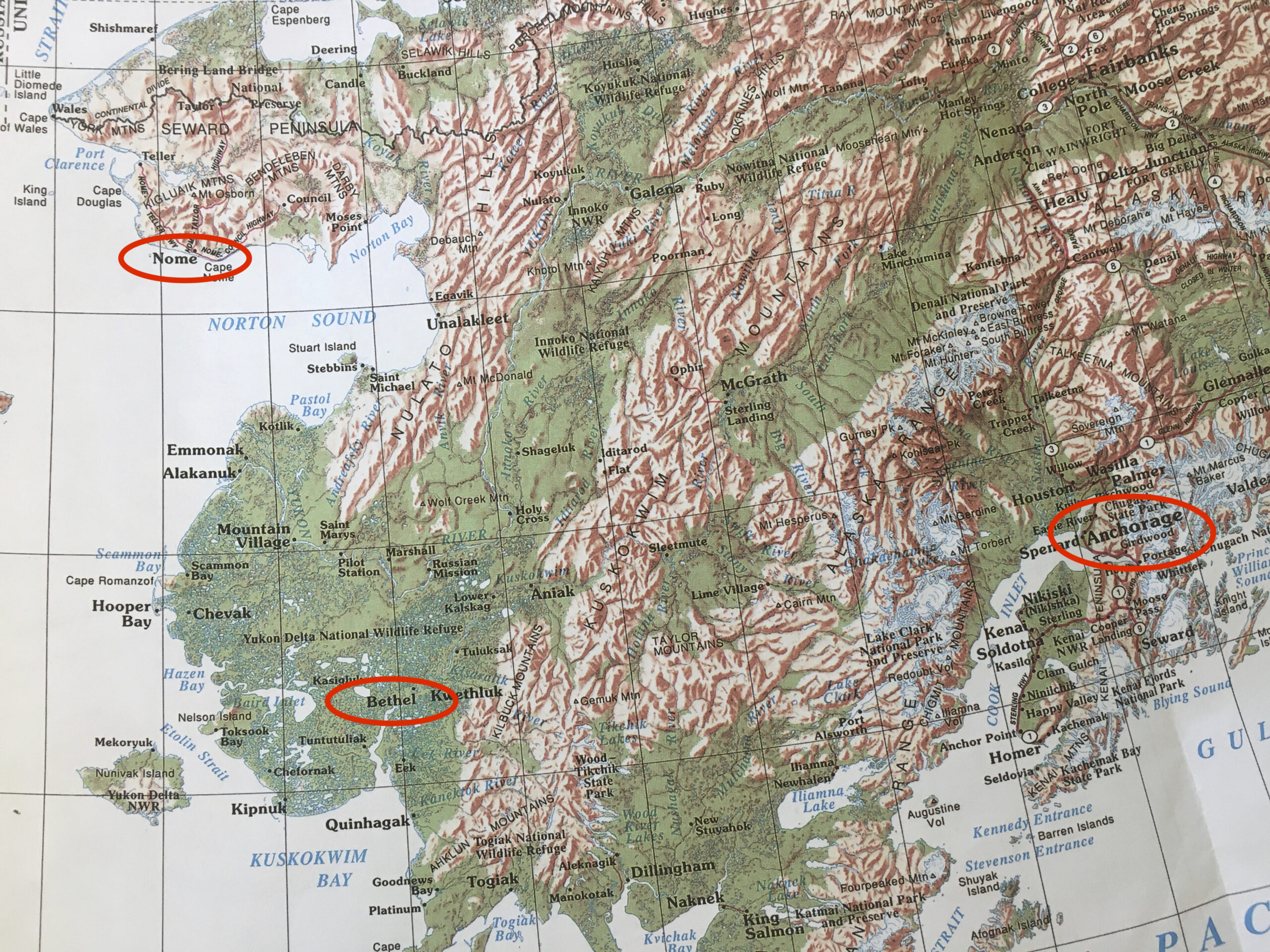
Nome is a mere 55 miles from the Russian coastline. Located in the Bering Strait, separating Alaska and Russia, are two (small) islands known as Big Diomede and Little Diomede. Big Diomede is owned by Russia while Little Diomede is owned by the US. The stretch of water between the two islands is only about 2.5 miles wide and actually freezes over during the winter so you could technically walk from the US to Russia on seasonal sea ice. Nome is also notable as it’s the finish line for the Iditarod – the 1,150-mile dogsled race that begins in Anchorage. We didn’t select this destination for its geography or its history although there is much to learn.
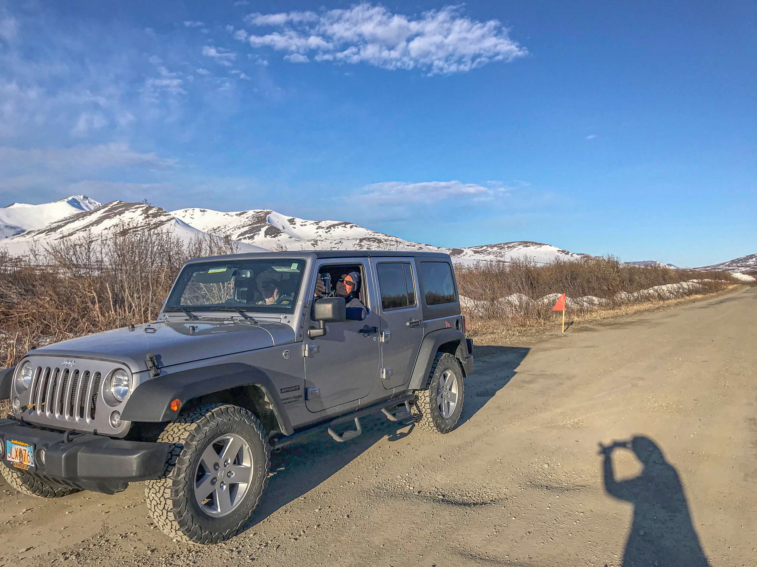
The way we chose to bird the area was by renting a car and driving sections of the 3 major roads that take visitors into geographically different environments. The Teller Road is about 70 miles total and connects Nome with the coastal town of Teller. It passes through rolling hills of Tundra and shrubs, crosses some rivers, and features craggy mountains that attract, interestingly, several species of birds we commonly see in Southern Oregon. We also spotted the remarkable Muskox in several locations.
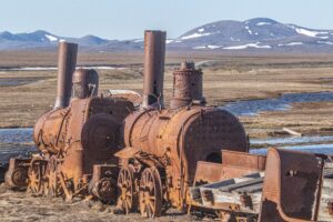
The 72-mile Nome-Council Road travels east from Nome, following the shore of the Bering Sea until it reaches the end of an abandoned narrow-gauge railroad (nicknamed “The Last Train to Nowhere”). The section along the coast is part of the Iditarod Trail and extends for 35 miles along a spit of wind-swept low brush peppered with occasional floater logs.Then it heads up into the hills and forest.
The 3rd road splits the two routes and is called the Kougarok Road. That one parallels the Nome River and in no time we viewed rocky bluffs housing Golden Eagles and Gyrfalcons. To be honest, we’d had our fill of “Baldies” in Unalaska/Dutch Harbor and we were happy searching for land birds.
We’d connected with a local birder, Carol Gales, who guides visitors during the brief tourist season (learn more at Roam Nome). Our strategy throughout our trip was to employ guides when available to maximize the likelihood of seeing our key birds. During these day trips, we’d pepper the guide with questions about potential solo routes, scribble notes on our maps, and then use our rental vehicle to follow-up on areas of interest. We planned this trip to coincide with birds breeding in Alaska. In late May and early June, a nondescript flyer that winters in warmer climes may produce gorgeous colors when they arrive in their “breeding” grounds in Alaska.
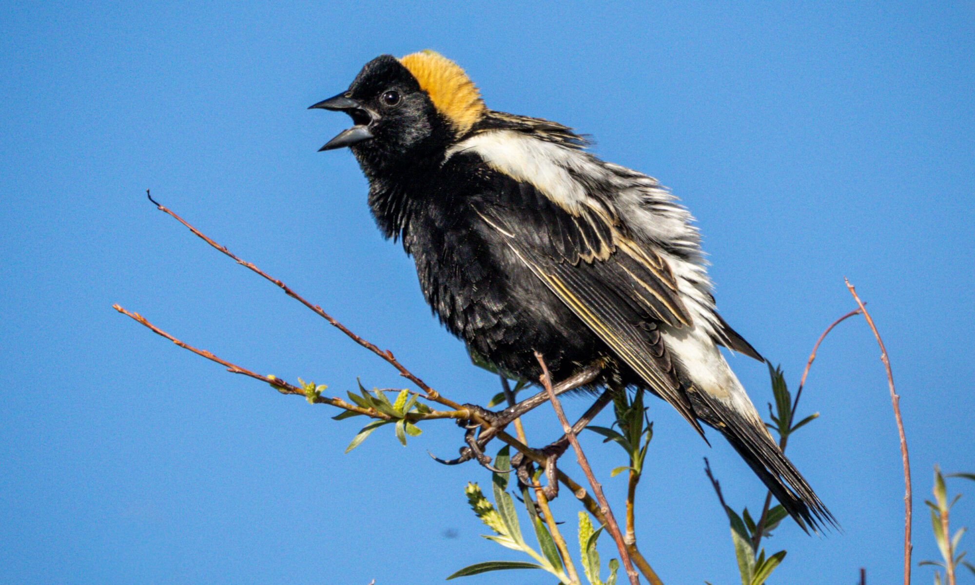
Being integrated into Arctic conditions, there were a couple key birds known primarily to nest in this chilly terrain: the Bristle-thighed Curlew, the Bluethroat, and the Arctic Warbler that hangs out in the Philippines during the off season. The mere names of these birds might make non-birders roll their eyes in wonderment. We’ve thankfully learned there’s SO much more to birding than merely viewing, and we enjoy traveling with dear friends who share the excitement of the hunt. Admittedly, even I roll my eyes when the difference between two species is the hue of the eyebrows of otherwise identical birds. For others, bliss.
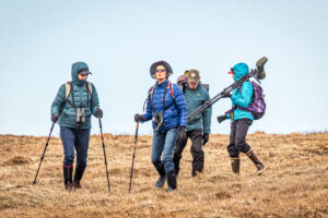
Ever since striking out looking out for the Snow Bunting in Dutch Harbor, we added that elusive bird to our want list. Using two cars connected with radios, we screamed along the Kougarok Road for approximately 72 miles, navigating around potholes and looking for a nondescript trail marked with a pair of sneakers attached to a post. Only the post had fallen down so we particularly grateful for Carol’s knowledge of the area. She was spot on, because moments later 2 other vehicles approached from Nome, parked, and disgorged a dozen more birders. So there we all were—most of us thankfully wearing high rubber boots, others even bearing scopes—climbing a mushy tundra-covered hill in search of the elusive Curlew. It shares the same terrain with Whimbrels and we initially saw that bird as well. Trekking along in the spongy surface was slow going, and occasionally water would ooze out of the moist soil and cover our boots. Nothing broke the uniform horizon, however, except for the intrepid Lapland Longspur and Savannah Sparrow. In the distance were the smooth to rocky contours of beautiful snow-covered mountains. But not a tree in sight. Carol had visited the area a couple days earlier with clients, and we more or less followed her established “path.” At one point, we tied Sooney’s Yosemite National Park bandana to a small willow shrub as a trail marker. From then on, we were on our own, with Arctic Terns and Jaegers riding the wind above us.

For some reason, most of the birders focused on a group of Whimbrels spotted on a ridge farther ahead. I chose a different route and, as luck would have it, our target bird showed up. Flying not far in front of me at about 3’, I captured some images of the bird and then signaled to everyone to join the party. The Curlew wasn’t the least bit shy and proceeded to munch away on tasty bits of the soft tundra. We also spotted the Bar-tailed Godwit that holds the distinction as one of nature’s longest flyers. After fattening up in Alaska, the Godwit flies roughly 7,000 miles (non-stop!) to New Zealand. Some have recently been documented flying at altitudes of three to four miles above ground in order to maximize the lighter air for flight efficiency. The Godwit covers the entire distance in 8-10 days! Even more astonishing, after breeding and fattening up in Alaska, the parent bird takes off on its marathon journey and leaves its offspring behind. They, in turn, continue gaining weight for an additional 3 weeks and then perform the marathon on their own without parents to show them the way. There’s as fascinating documentary on PBS’s Nature, titled Flyways, that “Follows a conservation movement of bird-loving experts and citizen scientists as they mobilize to the challenge of understanding and saving shorebirds.”
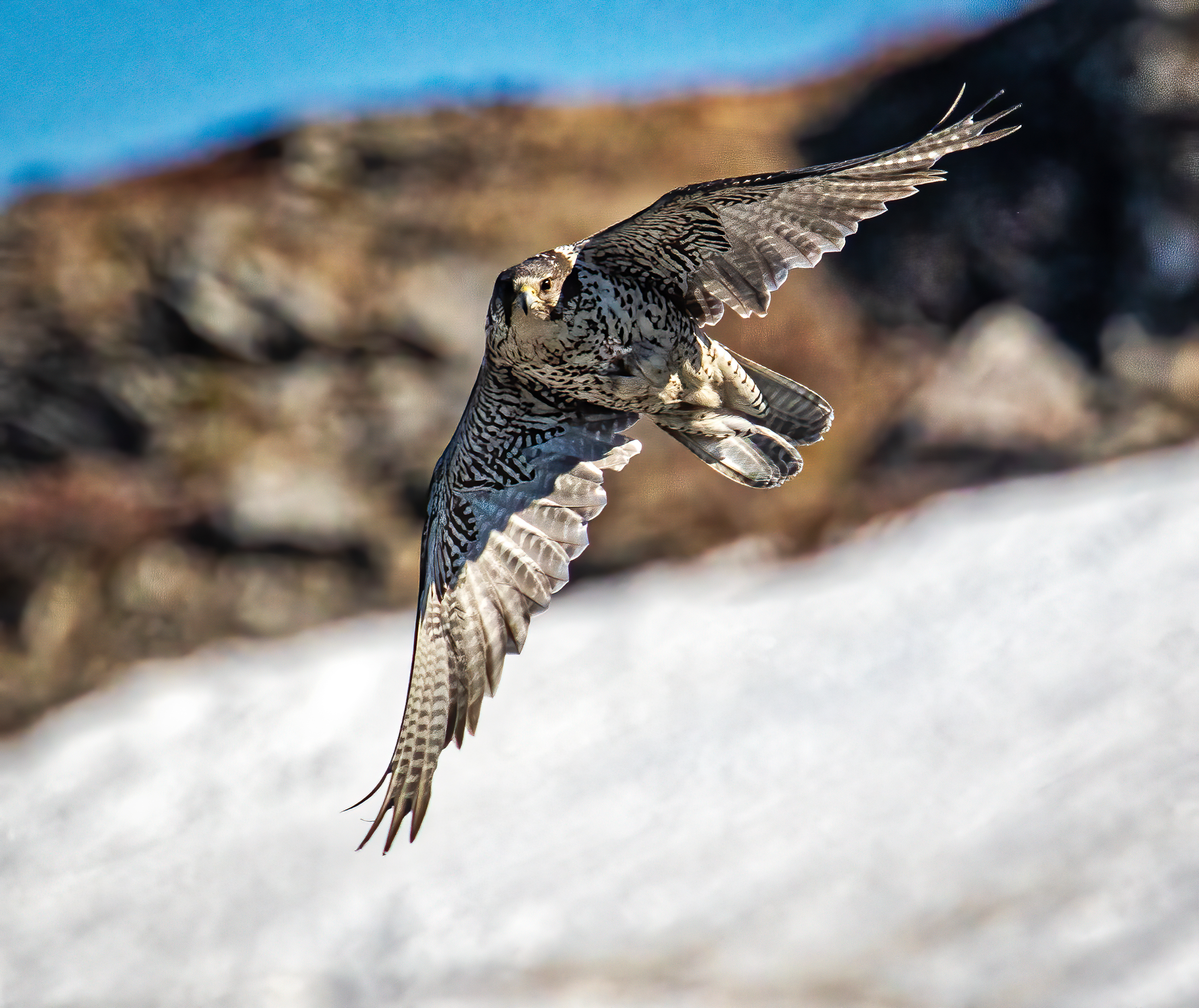
Without a guide but plenty of notes, we explored 53 miles of the Council Hwy. The coastal section splits the spit from the Bering Sea, and is mostly private land with native fish camps and odd assortments of rusting vehicles. There are a few waysides with access to ponds full of shorebirds, ducks and, to our great pleasure, Eiders (both the King and Common species). After 30 miles or so the road leaves the coastal Iditarod trail and follows the Solomon River into the foothills, meandering past abandoned gold dredges, collapsing structures, and a lonesome cemetery—all that’s left of the abandoned town of Dickson. Snookum Pass had just recently been cleared, although the road was pretty snarky. Miles farther is the town of Council, but a washed out road and lack of a ferry convinced us to bail on that plan and return the way we’d come. By then the light was warmer, and a key sighting was a pair of Gyrfalcons soaring above the snow covered bluffs above the river. While ostensibly hunting, they would occasionally sweep by us observers on the East Fork Bridge, much to our delight. It was only later that we spotted their nest right beneath the bridge’s handrails where we were standing. We were fortunate not to have intimidated the birds as they can be vicious when threatened.

Our second outing with Carol was on the Teller Road. Our goal was a small shorebird called a Red Knot, and we spotted one right away by turning off the main dirt highway onto a narrower dirt road at milepost 35. The trouble was we were in 30-mile winds that make holding a 500mm lens tough. Even standing was tough, because the terrain was spotted with glacial debris in small stony clusters. Between the rock mounds was tundra in blazing colors. Oh, and I forgot to mention that it was really cold. We spotted a couple Muskox that are equipped with multiple inches of insulation protecting them from the elements. Interestingly, wherever Muskox roam they leave telltale bits of their soft undercoat, called qiviut, attached to branches. This is spun into yarn and used by knitters to make warm scarves and hats. Sooney collected a bunch for a weaver we know back in Ashland.
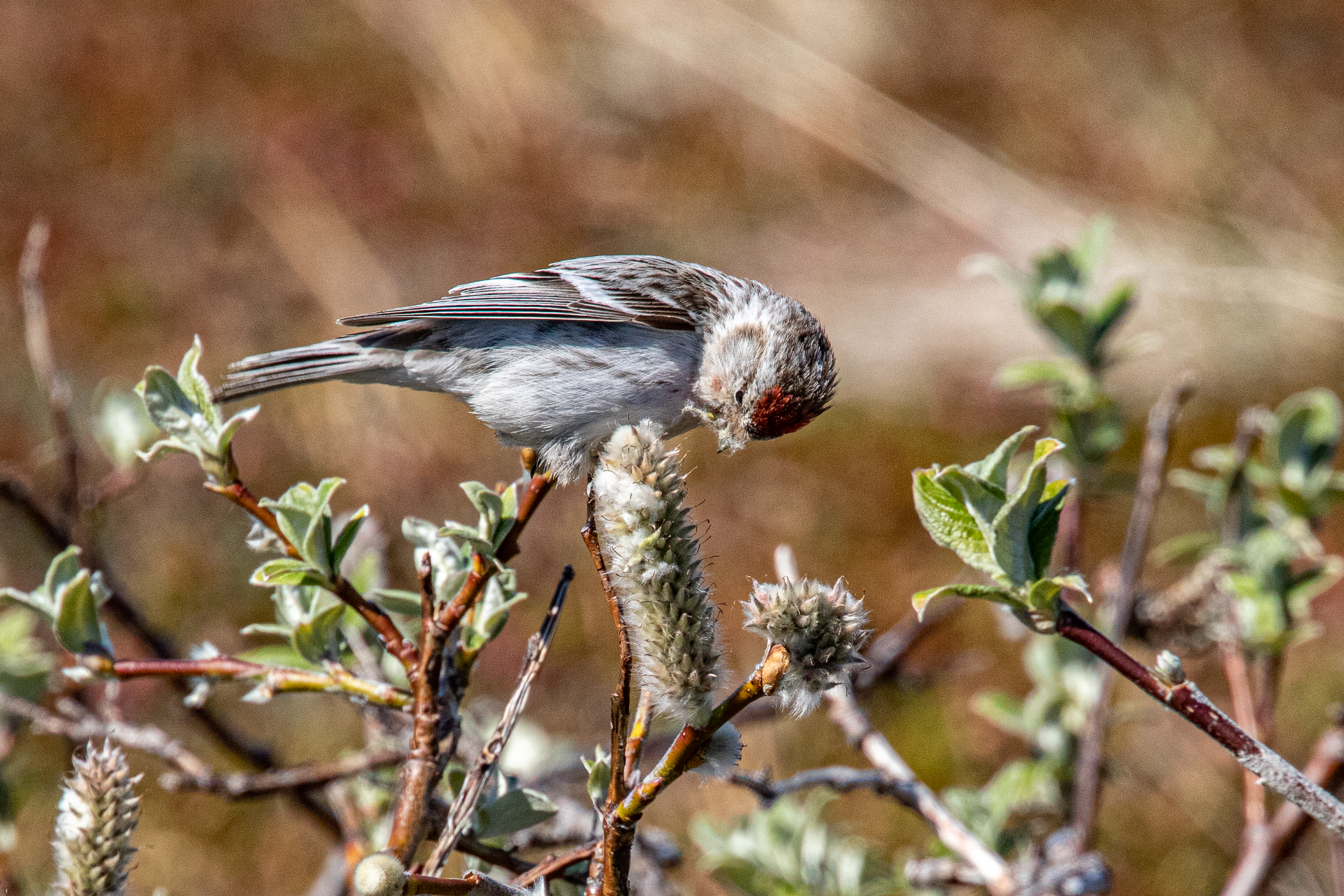
After eating our sandwiches and being entertained by a gorgeous Rough-legged Hawk cavorting in the strong winds above Wooly Lagoon Road, Carol left us to explore independently and we enjoyed the extended daylight with frequent stops. With only disappointing views of Snowy Buntings, one memorable visit was with a Hoary Redpoll ripping away at a Catkin seed pod. Overseeing the Redpoll was a cute Wheatear with its baby-blue/gray crown. This is how we birded throughout the trip, and we continued moseying to our hotel with stops for a Moose, a discrete view of some Arctic Terns copulating on a rock beneath a bridge, and finally at a nest of Golden Eagles on some bluffs about 10 miles from town. Having a rental car for independence, very talented birding companions, and a well-researched route each day, we weren’t terribly disappointed at not seeing the Arctic Warbler or a better look at a Bluethroat, and were pleased with the variety of wildlife we DID observe.
We closed out our Nome visit with some hotspots recommended by other birders. One was the water-treatment pond, so we asked around for directions, parked inside the open gate, and began birding the pond. All to ourselves, some Arctic Terns began swooping down on Sooney that made her uncomfortable as we’ve heard tales of similar behavior. After a few moments, however, we were saved by a friendly guy in a white pickup with some hard-to-read logo on the door of his cab.
“Welcome to Nome. You must be new here.” He introduced himself as the treatment facility administrator and said we were not permitted to bird there. He pointed to the other side of the chainlink fence and said many nice birds had been seen there. We weren’t quite sure how to get there, however, so be said, “Follow me,” and jumped back into his pickup and drove us to the safest place on the beach to park our Jeep with access to some companion ponds. We were treated to several nesting Aleutian Terns, a Red-throated Loon, and a gorgeous pair of Long-tailed ducks in blazing mating plumage floating not 100 yards from those forbidden treatment pools. We waved our thanks to him, and certainly could have stayed a few more days in Nome. But flights were booked to Bethel and Utqiágvik (Barrow), so off we continued on our adventures. Stay tuned.
I’ve compiled a collection of photos into a gallery featuring this leg of our journey. Enjoy!